Chart data for Olex
Following Navionics owners’ strategic decision to focus on their recreational business the Navionics charts were withdrawn from supply to professional users. The Navionics chart folios officially ceased to be available and this does also affect their supply to OLEX users. The last update of Navionics data for the existing users is planned for November 2021.
OLEX can use official and unofficial vector charts, in S57, shape, and SOSI format, from Hydrographic Offices and commercial vendors. Effective immediately, as an alternative to older Navionics charts for OLEX users the following chart options, in S-63 format, will be available:
- Official ENC which is compiled by the Hellenic Navy Hydrographic Service (HNHS) of Greece in compliance with the S-57 Ed3.1 standard of the International Hydrographic Organization (IHO). These charts are mostly intended for professional Electronic Chart Display Information Systems (ECDIS). ENCs for ECDIS are made available encrypted with the IHO S-63 standard. They can also be used by any other non-ECDIS system that can read S-63 encrypted S57 Ed. 3.1 data, such as OLEX.
- C-Map provides electronic charts which are based on ENCs and additional sources, mainly paper charts, published by hydrographic offices. C-Map chart folios are designed for commercial users who would need larger area coverage for non-SOLAS applications. The charts are updated over time, to include ENC updates and Notices to Mariners, published by hydrographic offices.
- ChartWorld provides vector nautical charts derived from S-57 data produced and licensed by national HOs for non-SOLAS applications only. ChartWorld digital charts include data from the following HOs: Canada, Norway, Denmark, Belgium, Germany, Iceland, Sweden, the Netherlands, the United Kingdom, and the USA. Other countries are being regularly added to the service.
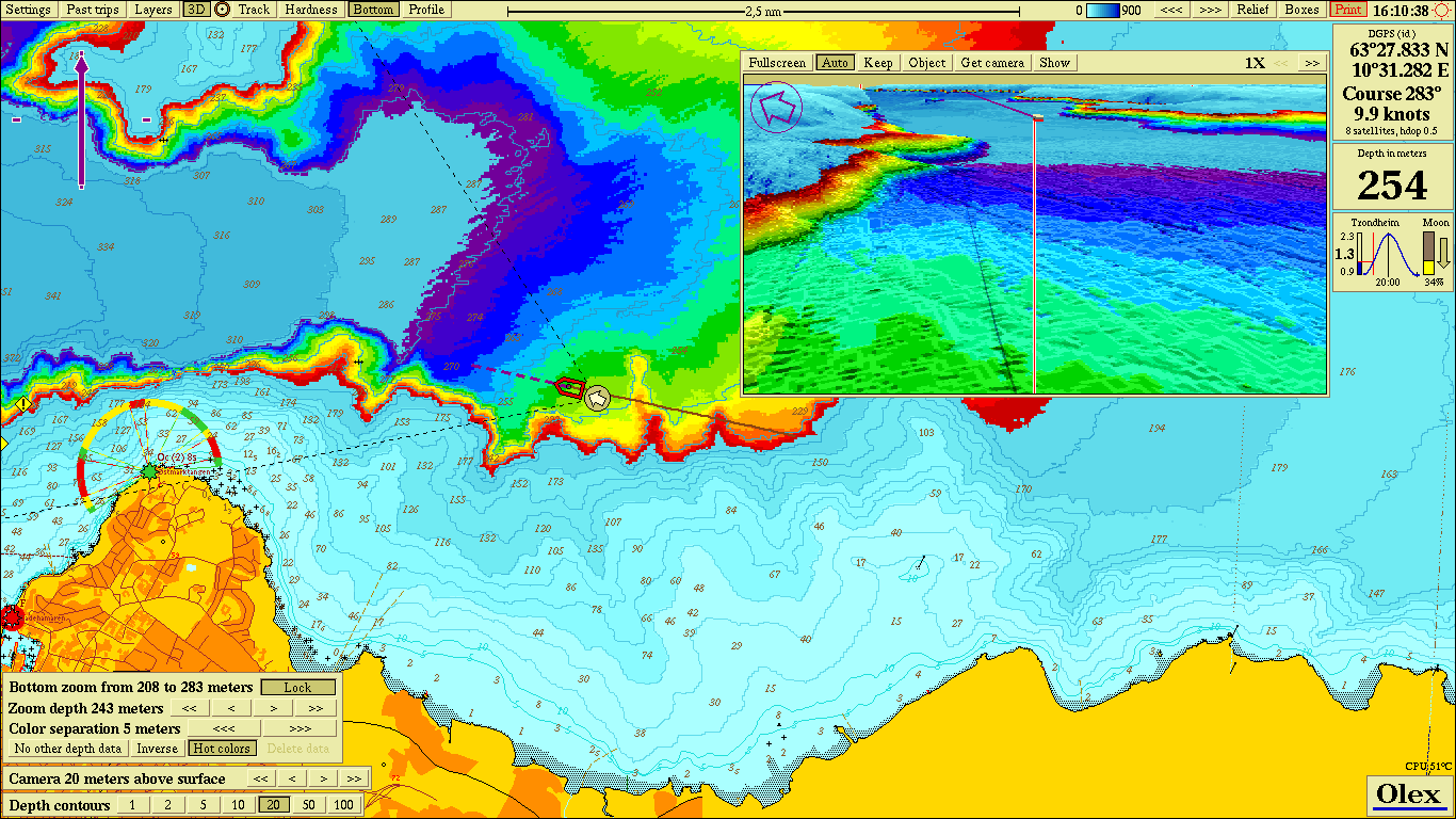
After years of research, development, and testing, OLEX AS has developed and keeps refining the most comprehensive seafloor topography mapping system available on the market. OLEX systems are based on Linux and are considered to be the most stable systems of their kind available on the commercial market. Speed, flexibility, and user-friendliness are important keywords to explain their success.
OLEX can use official and unofficial vector charts, in S57, shape, and SOSI format, from Hydrographic Offices and commercial vendors. The navigation charts are displayed alongside the collected seabed data and the chart visualization software will always strive to achieve a clear and informative chart image and prevent the screen from filling up with unnecessary information, by displaying only information relevant to the current zoom scale. Zooming and chart display is fast, easy, and seamless.
For further information you may contact the Official Distributor and Support Center for Greece and Cyprus:
Aegean Electronics SA
4 Zosimadon Str, Piraeus 185 31, Greece
Tel: +30 210 4123000
E-mail: info@aegeanel.com
Recent Posts
- SEA.AI Sailing Software Update v8.0
- B&G released new software for Nemesis
- Simrad introduces new HS65 Satellite Compass
- Anschütz Std22NX gyrocompass with 3-years warranty
- Simrad launched ECS900 Electronic Chart System
- ShipModul released firmware V3.20.0 for MPXConfig3
- New SYNAPSIS software enhances bridge performance
- Simrad SY60 a new 8-inch Omni Sonar
- OLEX releases version 17.11
- ShipModul released firmware V3.38.x for MiniPlex-3
- Echoview 16.1 is out now!
- B&G® announced the new Zeus®SRX
- SAILOR 4065 EPIRB GNSS/AIS is launched
- Simrad released s.v.26.1 for NSS & NSO evo3/3S
Archives
- July 2026
- June 2026
- May 2026
- April 2026
- March 2026
- February 2026
- January 2026
- December 2025
- November 2025
- October 2025
- September 2025
- August 2025
- July 2025
- June 2025
- May 2025
- April 2025
- March 2025
- February 2025
- January 2025
- December 2024
- November 2024
- October 2024
- September 2024
- August 2024
- July 2024
- June 2024
- May 2024
- April 2024
- March 2024
- February 2024
- January 2024
- December 2023
- November 2023
- October 2023
- September 2023
- August 2023
- July 2023
- June 2023
- May 2023
- April 2023
- March 2023
- February 2023
- January 2023
- December 2022
- November 2022
- October 2022
- September 2022
- August 2022
- July 2022
- June 2022
- May 2022
- April 2022
- March 2022
- February 2022
- January 2022
- December 2021
- November 2021
- October 2021
- September 2021
- August 2021
- July 2021
- June 2021
- May 2021
- April 2021
- March 2021
- February 2021
- January 2021
- December 2020
- November 2020
- October 2020
- September 2020
- August 2020
- July 2020
- June 2020
- May 2020
- April 2020
- March 2020
- February 2020
- January 2020
- December 2019
- November 2019
- October 2019
- September 2019
- July 2019
- June 2019
- April 2019
- March 2019
- February 2019
- January 2019
- December 2018
- November 2018
- October 2018
- September 2018
- July 2018
- June 2018
- May 2018
- April 2018
- March 2018
- February 2018
- January 2018
- December 2017
- October 2017
- February 2017
- January 2017
- April 2016