OLEX 11.6 released!
Norwegian based OLEX AS, the manufacturer of complete systems for navigation, plotting and 3D seafloor mapping, is pleased to announce that OLEX 11.6 is now released and available as a free download or through your local Olex dealer for an upgrade of your system. OLEX 11.6 is optimized for the newest distributions of Scientific Linux (SL) 7.6 and 6.10 which are a free and open source operating systems supported by a cooperative of science labs and universities. Plus various other improvements and bug fixes are also included, like SIMRAD sounder connections coupled with GRIB, etc.
The most important change of this latest release is the use of a new BIOS based id/nokkel format which supports storage like NVMe and the newest CPUs. NVMe is an open spec logical device interface used for accessing non-volatile storage media attached via a PCI Express (PCIe) bus. It has been designed to allow the processing hardware and software to fully exploit the internal parallelism and low latency available in modern SSDs. As a result, NVMe reduces throughput overheads and brings various performance improvements relative to previous types of interfaces which were designed within the parameters of older RAM speed and disc rotation restrictions in mind. Moreover, all new OLEX systems will now make use of BIOS hints for authentication, instead of hard-disk fingerprints. This means one can now replace a defective hard-drive and reuse the old id/nokkel. At the same time, a new id/nokkel will be needed if central components like the motherboard are swapped. We feel this is more pragmatic: hard-disks break more often than motherboards. Older systems are of course supported as always.
So a short-list of the OLEX 11.6 release notes is:
- Support for Scientific Linux 7.6 and 6.10
- New BIOS based id/nokkel format, to support storage like NVMe
- Plotter data from ECC Globe via Microsoft Access -> CVS
- Minor: subtle rounding improvement of deeper mapped depths
- Minor: ergonomic improvements, empty AIS username/password
- Minor: UDP debugging, Spectre and Meltdown mitigation
- Minor: heave graph, fancy bathymetry grayscale logic
- Bug fixes: Firewall on SL6.10, disused MAC address
- Bug fixes: Malformed Ruter data, AIS ghost button
- Bug fixes: Automated Ruter cleaning, multifile XYZ export
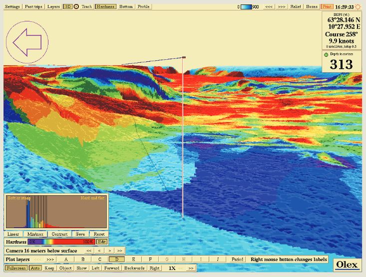
After years of research, development, and testing, OLEX AS has developed and keeps refining the most comprehensive seafloor topography mapping system available on the market. OLEX systems are based on Linux, and are considered to be the most stable systems of their kind available on the commercial market. Speed, flexibility, and user-friendliness are important keywords to explain their success.
OLEX can use official and unofficial vector charts, in S57, shape and SOSI format, from Hydrographic Offices and commercial vendors. The navigation charts are displayed alongside the collected seabed data and the chart visualization software will always strive to achieve a clear and informative chart image and prevent the screen from filling up with unnecessary information, by displaying only information relevant to the current zoom scale. Zooming and chart display are fast, easy and seamless.
For further information you may contact the Official Distributor and Support Center for Greece and Cyprus:
Aegean Electronics SA
4 Zosimadon Str, Piraeus 185 31, Greece
Tel: +30 210 4123000
E-mail: info@aegeanel.com
Recent Posts
- SEA.AI Sailing Software Update v8.0
- B&G released new software for Nemesis
- Simrad introduces new HS65 Satellite Compass
- Anschütz Std22NX gyrocompass with 3-years warranty
- Simrad launched ECS900 Electronic Chart System
- ShipModul released firmware V3.20.0 for MPXConfig3
- New SYNAPSIS software enhances bridge performance
- Simrad SY60 a new 8-inch Omni Sonar
- OLEX releases version 17.11
- ShipModul released firmware V3.38.x for MiniPlex-3
- Echoview 16.1 is out now!
- B&G® announced the new Zeus®SRX
- SAILOR 4065 EPIRB GNSS/AIS is launched
- Simrad released s.v.26.1 for NSS & NSO evo3/3S
Archives
- July 2026
- June 2026
- May 2026
- April 2026
- March 2026
- February 2026
- January 2026
- December 2025
- November 2025
- October 2025
- September 2025
- August 2025
- July 2025
- June 2025
- May 2025
- April 2025
- March 2025
- February 2025
- January 2025
- December 2024
- November 2024
- October 2024
- September 2024
- August 2024
- July 2024
- June 2024
- May 2024
- April 2024
- March 2024
- February 2024
- January 2024
- December 2023
- November 2023
- October 2023
- September 2023
- August 2023
- July 2023
- June 2023
- May 2023
- April 2023
- March 2023
- February 2023
- January 2023
- December 2022
- November 2022
- October 2022
- September 2022
- August 2022
- July 2022
- June 2022
- May 2022
- April 2022
- March 2022
- February 2022
- January 2022
- December 2021
- November 2021
- October 2021
- September 2021
- August 2021
- July 2021
- June 2021
- May 2021
- April 2021
- March 2021
- February 2021
- January 2021
- December 2020
- November 2020
- October 2020
- September 2020
- August 2020
- July 2020
- June 2020
- May 2020
- April 2020
- March 2020
- February 2020
- January 2020
- December 2019
- November 2019
- October 2019
- September 2019
- July 2019
- June 2019
- April 2019
- March 2019
- February 2019
- January 2019
- December 2018
- November 2018
- October 2018
- September 2018
- July 2018
- June 2018
- May 2018
- April 2018
- March 2018
- February 2018
- January 2018
- December 2017
- October 2017
- February 2017
- January 2017
- April 2016