Simrad App on iOS and Android, for boating
The latest Simrad® App, from the marine electronics leader celebrating its 75th anniversary this year, was released. The updated app includes a premium offering complete with new mapping features, advanced functionality, and mirroring and control of Simrad® multi-functional displays from your smartphone or tablet. It is available on both the Apple Store for iOS and Google Play for Android.
The app is free to download and offers a rich experience that includes free up-to-date nautical charts from C-MAP®, personal waypoints, routes and tracks, the latest marine weather, personalization, and much more. The app also allows you to register your Simrad® device(s) ensuring you have the latest software, manuals, information, and product tips, as well as the ability to synchronize your waypoints and routes. The premium version has additional functionalities including stand-alone navigation.
“The new mirroring feature allows you to view and direct your Simrad electronics from anywhere on the boat right from the palm of your hand,” said James Methven, Global Head of Brand, Simrad Yachting. “This easy integration with companion devices along with intuitive C-MAP charts and features make the Simrad® app a no-brainer for any Simrad® user to download and use.”
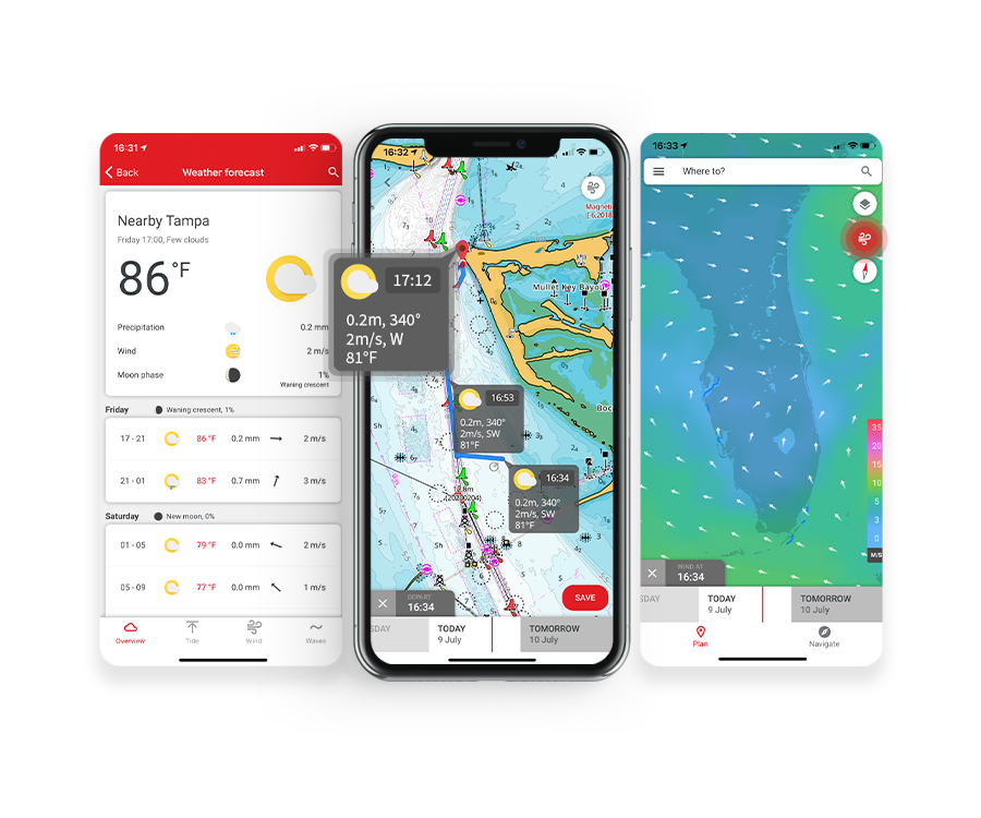
The premium version of the Simrad® App offers Global charts and offline maps, High-Resolution Bathymetry Charts, Automatic Identification System (AIS), Simrad® Community Traffic, 5-day weather overlay along the route, and 5-day weather overlay, GPS navigation data, and line, track recording plus custom depth shading. The full complement of weather data is provided in both versions including wind data, sea state, tides and currents, water temperature, and much more. The Simrad® App also features detailed fishing information for anglers and sport fishing enthusiasts.
“The simplified ‘freemium’ option provides a long list of technology and functionality right to your smartphone or tablet at no cost to enable your fishing, yachting, and powerboating experience near shore or offshore,” added Methven. “Plus, now we provide the option for an easy annual subscription upgrade to receive crucial premium features like offline charting and enhanced GPS data, custom depth shading, and our new weather overlay for 5-days along your route.”
The C-MAP charts on the app are carefully designed to highlight what is most important at any given time during your boating experience, maintaining accuracy and a clean, uncluttered view. Charts are powered by data from official hydrographic offices and continuously updated and augmented from thousands of data sources to enrich data near shore or offshore to provide clarity for your routing, whether that’s a short trip across the bay or a longer voyage on the open water.
FREE
- Up-to-date nautical charts
- Personal waypoints, routes, and tracks
- Manual and Autorouting
- Measure distance tool
- Thousands of Points of Interest
- Marine weather forecast
- Weather along the route for 24 hours
- Weather overlay for 24 hours
- GPX import and export
- Chart personalization:
- boat size,
- favorite units of measurement,
- favorite map type or view mode (Auto, light, or dark)
- Device registration
- Device support: manuals, guides, videos
- NEW: Mirroring and Control
- NEW: Offline sync of WRnT
PREMIUM (includes everything in FREE, plus):
- Offline maps (Global chart)
- AIS
- 5-day weather along the route
- Navigation: GPS data, navigation line, track record
- Traffic: keep an eye on other app users around
- NEW: 5-day weather overlay
- NEW: High-resolution Bathymetry
- NEW: Custom Depth Shading
- NEW: Shaded Relief
For further information you may contact the Official Distributor and Support Center for Greece:
Aegean Electronics SA
4 Zosimadon Str, Piraeus 185 31, Greece
Tel: +30 210 4123000
Recent Posts
- SEA.AI Sailing Software Update v8.0
- B&G released new software for Nemesis
- Simrad introduces new HS65 Satellite Compass
- Anschütz Std22NX gyrocompass with 3-years warranty
- Simrad launched ECS900 Electronic Chart System
- ShipModul released firmware V3.20.0 for MPXConfig3
- New SYNAPSIS software enhances bridge performance
- Simrad SY60 a new 8-inch Omni Sonar
- OLEX releases version 17.11
- ShipModul released firmware V3.38.x for MiniPlex-3
- Echoview 16.1 is out now!
- B&G® announced the new Zeus®SRX
- SAILOR 4065 EPIRB GNSS/AIS is launched
- Simrad released s.v.26.1 for NSS & NSO evo3/3S
Archives
- July 2026
- June 2026
- May 2026
- April 2026
- March 2026
- February 2026
- January 2026
- December 2025
- November 2025
- October 2025
- September 2025
- August 2025
- July 2025
- June 2025
- May 2025
- April 2025
- March 2025
- February 2025
- January 2025
- December 2024
- November 2024
- October 2024
- September 2024
- August 2024
- July 2024
- June 2024
- May 2024
- April 2024
- March 2024
- February 2024
- January 2024
- December 2023
- November 2023
- October 2023
- September 2023
- August 2023
- July 2023
- June 2023
- May 2023
- April 2023
- March 2023
- February 2023
- January 2023
- December 2022
- November 2022
- October 2022
- September 2022
- August 2022
- July 2022
- June 2022
- May 2022
- April 2022
- March 2022
- February 2022
- January 2022
- December 2021
- November 2021
- October 2021
- September 2021
- August 2021
- July 2021
- June 2021
- May 2021
- April 2021
- March 2021
- February 2021
- January 2021
- December 2020
- November 2020
- October 2020
- September 2020
- August 2020
- July 2020
- June 2020
- May 2020
- April 2020
- March 2020
- February 2020
- January 2020
- December 2019
- November 2019
- October 2019
- September 2019
- July 2019
- June 2019
- April 2019
- March 2019
- February 2019
- January 2019
- December 2018
- November 2018
- October 2018
- September 2018
- July 2018
- June 2018
- May 2018
- April 2018
- March 2018
- February 2018
- January 2018
- December 2017
- October 2017
- February 2017
- January 2017
- April 2016