JMC releases s.v.5.4.0R for SP MAX III
JMC announced the release of software version 5.4.0R for Professional Chart Plotter Super Pilot MAX III. Considering the functionality added and the enhanced user experience allowed, it is recommended that existing systems with older software (i.e. 5.3.xR, 4.x.xR, 3.x.x) to be upgraded to the new version. A new User Manual is built-into the system menu and is also available as pdf file or as a printed document from local dealers. Using this latest software update the JMC SP MAX III remains the top choice of those looking for a rugged, easy-to-use Professional Chart Plotter.
WARNING: Marine Software Family 5.x.xR (including all versions starting from release 5.0.0R), is NOT COMPATIBLE with any legacy NON-CHIRP Black Box Fish Finder modules, such as JMC V-6100.
New features which were added to SP MAX III with the latest s.v5.4.0R are:
Navionics, related:
- Management of sonar logs for Sonar Chart Live
- Management and viewing of Community Edits update
- Viewing of Satellite Overlay and Sonar Chart Shading
- Dynamic Data displays for Tides and Currents
- Various minor improvements and bug-fixing
A new Instruments Page is available, which includes:
- 3D Road
- Wind
- Rate of Turn
- Rudder
- Timer
- Multi & Single Databox
- Temperature
- Pitch and Roll
- Compass
- Speed
- Depth Graph
- Engine
Existing SP MAX III features which were improved are:
AIS
- AIS list/setting access improved
- AIS tracking added (without recording)
- AIS target size option added
- AIS menus, sub-menus, and info-windows generally improved
- “Show vector COG” and “COG vector time” added to AIS settings
- “Search vessel” added to AIS list options
- Un-acquired “static message” targets added in AIS list
- “AIS class selection” added
- CPA/TCPA Alarm setting decimal digit has been improved
Radar
- Radar image quality improved
- “Show Radar” OFF in MAP split screen
- Radar rings OFF improved
Fish Finder
- Improved noise management and target detection, esp. for shallow and medium depths
- Improved multiple echo management to avoid false bottom detection
- Time Bar display improved
- Zero depth value displayed when no depth input
- White marker behavior improved
- Ping rate / Auto Ping explanation added to User Manual
- Added three Airmar transducers
Other
- “Bottom Lost” alarm added
- “No Heading” icon added to the status bar
- Ship icon size option added
- Faster access to AIS, DSC, and Data lists/settings via shortcuts from the Quick Setting menu
- COG/SOG damping improvement via the new GPS setup menu
- “Distance & Heading to Cursor” databox added
- Internal GPS restart popup notification added
- Zoom, Direction, and Radar Tx buttons visibility improved
- Slider menu speed behavior improved
- Captain Cloud: enabled synching for user data created offline
- Added new C-Map LIB fixing rare crashing issue during long session conditions
Chart Plotting systems display information from electronic charts and integrate information from the Global Navigation Satellite System (GNSS) and other sensors, (AIS, etc) to create an aid for safe navigation. In the JMC SP MAX III, general navigation purposes are served from two levels of enhanced background map, which are embedded as standard, allowing global zoom up to 2 n.m. For detailed and updated information on specific areas, an extensive selection can be made from C-MAP (4D, MAX) and Navionics Charts in a micro SD format. Using these detailed charts makes available the assisted routing functionality menus; Easy Routing for C-Map 4D Charts or Autorouting for Navionics Charts. Furthermore, an optional FishFinder module (BV-6200) can be connected and operated allowing connection to selected CHIRP transducers at various frequency bands between 45 to 210 kHz and up to 1 kW of power output. Compatibility with older CW transducers of vintage JMC Echo Sounders and others is also provided, with the same module, at single or dual frequencies (50/200 kHz) and output power of 600 W or 1 kW. Multiple external I/O connections (1 X NMEA-2000 and 2 X NMEA-0183) also provide for interfacing with AIS, Wind data, Engine monitor, autopilot, etc. Wi-Fi plus Mirror Control functions, using the smartphone of Tablet PC, are also provided. The JMC SP MAX III Chart Plotter provides extensive and easy possibilities for customization to each user’s operational needs.
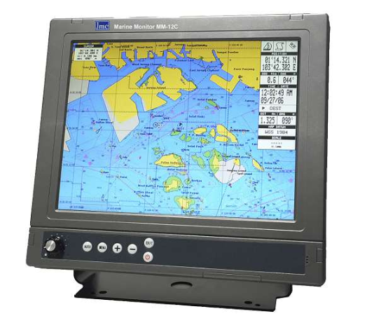
The standard JMC Super Pilot MAX III delivery consists of a compact control unit with an integrated chart card reader plus a high-performance 72-channel SBAS enhanced GNSS antenna with a 10-18Hz update rate. The use of an (optional) 12” or 17” JMC Marine Monitor is recommended for optimal performance. Nevertheless, any type of display can be used since both 4:3 and 16:9 aspect ratios are supported at various resolutions. A wireless control unit (2,4 GHz) is optionally available, giving full remote access to all plotter functions. The modular construction of the system allows for easy and ergonomic installation even in smaller vessels. While the one-touch menu keys of the control unit are conveniently backlit and are highlighted once activated, simplifying operation in low light conditions. Moreover, the simple Greek menu, as in all JMC Chart Plotters, is providing an intuitive and user-friendly interface.
For further information you may contact the Official Distributor and Support Center for Greece:
Aegean Electronics SA
4 Zosimadon Str, Piraeus 185 31, Greece
Tel: +30 210 4123000
E-mail: info@aegeanel.com
Recent Posts
- SEA.AI Sailing Software Update v8.0
- B&G released new software for Nemesis
- Simrad introduces new HS65 Satellite Compass
- Anschütz Std22NX gyrocompass with 3-years warranty
- Simrad launched ECS900 Electronic Chart System
- ShipModul released firmware V3.20.0 for MPXConfig3
- New SYNAPSIS software enhances bridge performance
- Simrad SY60 a new 8-inch Omni Sonar
- OLEX releases version 17.11
- ShipModul released firmware V3.38.x for MiniPlex-3
- Echoview 16.1 is out now!
- B&G® announced the new Zeus®SRX
- SAILOR 4065 EPIRB GNSS/AIS is launched
- Simrad released s.v.26.1 for NSS & NSO evo3/3S
Archives
- July 2026
- June 2026
- May 2026
- April 2026
- March 2026
- February 2026
- January 2026
- December 2025
- November 2025
- October 2025
- September 2025
- August 2025
- July 2025
- June 2025
- May 2025
- April 2025
- March 2025
- February 2025
- January 2025
- December 2024
- November 2024
- October 2024
- September 2024
- August 2024
- July 2024
- June 2024
- May 2024
- April 2024
- March 2024
- February 2024
- January 2024
- December 2023
- November 2023
- October 2023
- September 2023
- August 2023
- July 2023
- June 2023
- May 2023
- April 2023
- March 2023
- February 2023
- January 2023
- December 2022
- November 2022
- October 2022
- September 2022
- August 2022
- July 2022
- June 2022
- May 2022
- April 2022
- March 2022
- February 2022
- January 2022
- December 2021
- November 2021
- October 2021
- September 2021
- August 2021
- July 2021
- June 2021
- May 2021
- April 2021
- March 2021
- February 2021
- January 2021
- December 2020
- November 2020
- October 2020
- September 2020
- August 2020
- July 2020
- June 2020
- May 2020
- April 2020
- March 2020
- February 2020
- January 2020
- December 2019
- November 2019
- October 2019
- September 2019
- July 2019
- June 2019
- April 2019
- March 2019
- February 2019
- January 2019
- December 2018
- November 2018
- October 2018
- September 2018
- July 2018
- June 2018
- May 2018
- April 2018
- March 2018
- February 2018
- January 2018
- December 2017
- October 2017
- March 2017