C-Map DISCOVER & REVEAL
C-Map, a member of the Navico family of Brands, announced the replacement of all previous end-of-life MAX-N & MAX-N+ charts with the latest DISCOVER and REVEAL for Navico Group (Simrad, B&G, etc) chart-plotters. If within the 12-month free update period of the original chart the update to either type (depending the old chart type) will be free-of-charge. If the chart is older than 12 months an update cost will be applied. For MAX-N+ this update will usually be to a new DISCOVER chart. For existing Reveal users, Precision Contour HD, Lake Insight and Insight Pro, the update will be to a REVEAL chart. In all cases, users will benefit from the improved data and features in these new charts.
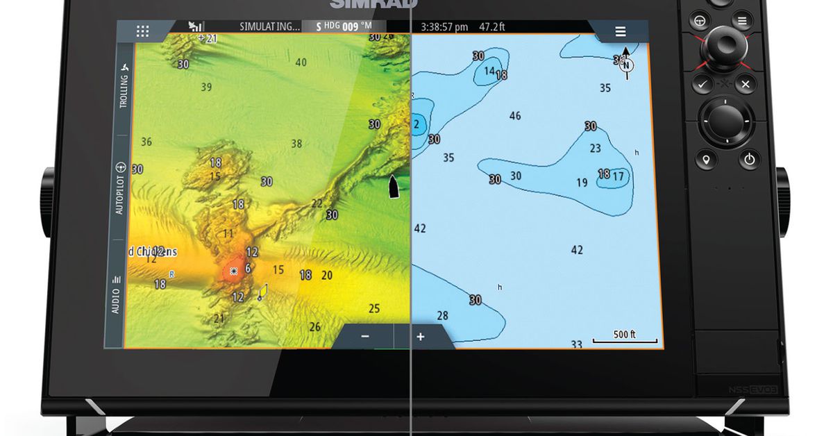
Furthermore, the unique features, available only to Simrad and B&G Chart-plotters, of Custom Depth Shading and Shaded Relief make C-Map charts the go-to-choice to power fishing, cruising or sailing. In particular, Custom Depth Shading provides many options to set a safety depth, maintain a paper like view or your own custom color for depths. While Shaded Relief brings the world around your vessel to life with 3D rendered land and underwater elevations.
C-Map DISCOVER are High Quality Entry-Level Charts including all the essentials, like:
- High-Res Bathymetry
- Nautical Charts
- Harbor & Port Plans
- Genesis Layer (available for selected areas)
- Custom Depth Shading
- Subscription-Free Easyrouting™
- Tides & Currents
C-Map REVEAL are Premium Quality Charts for the user (except Cruise-range) who wants it all. C-Map REVEAL includes all data and features in C-Map DISCOVER plus:
- Shaded Relief – Seafloor 3D Imagery provides attractive three-dimensional views of land elevation and bottom contours, bringing to life the world around your boat. Visualize underwater pinnacles and topographical landmarks easier than ever.
- High-resolution Satellite Imagery is an invaluable tool providing real-world reference and enhancing situational awareness for coastal navigation and fishing.
- Aerial Photos are a collection of thousands of photos of marinas, harbors, inlets and other notable navigational features included to offer an additional level of detail.
- Raster Charts provide a traditional chart look and feel coupled with easy access to all objects on the charts.
The World-class C-Map DISCOVER & REVEAL charts include all navigation information, ranging from depth areas and contours, spot soundings, navigation aids, moons, tides, currents, marine parks and more.
Simrad and B&G users, especially with the C-Map REVEAL charts, enter a new world of mapping and may view the sea floor in a whole new light. The clear identification of sea floor structure, along with reefs and ledges provides users with the information needed to find the best fishing, diving, cruising and anchoring spots.
For further information you may contact the Official Distributor and Support Center for Greece:
Aegean Electronics SA
4 Zosimadon Str, Piraeus 185 31, Greece
Tel: +30 210 4123000
Recent Posts
- SEA.AI Sailing Software Update v8.0
- B&G released new software for Nemesis
- Simrad introduces new HS65 Satellite Compass
- Anschütz Std22NX gyrocompass with 3-years warranty
- Simrad launched ECS900 Electronic Chart System
- ShipModul released firmware V3.20.0 for MPXConfig3
- New SYNAPSIS software enhances bridge performance
- Simrad SY60 a new 8-inch Omni Sonar
- OLEX releases version 17.11
- ShipModul released firmware V3.38.x for MiniPlex-3
- Echoview 16.1 is out now!
- B&G® announced the new Zeus®SRX
- SAILOR 4065 EPIRB GNSS/AIS is launched
- Simrad released s.v.26.1 for NSS & NSO evo3/3S
Archives
- July 2026
- June 2026
- May 2026
- April 2026
- March 2026
- February 2026
- January 2026
- December 2025
- November 2025
- October 2025
- September 2025
- August 2025
- July 2025
- June 2025
- May 2025
- April 2025
- March 2025
- February 2025
- January 2025
- December 2024
- November 2024
- October 2024
- September 2024
- August 2024
- July 2024
- June 2024
- May 2024
- April 2024
- March 2024
- February 2024
- January 2024
- December 2023
- November 2023
- October 2023
- September 2023
- August 2023
- July 2023
- June 2023
- May 2023
- April 2023
- March 2023
- February 2023
- January 2023
- December 2022
- November 2022
- October 2022
- September 2022
- August 2022
- July 2022
- June 2022
- May 2022
- April 2022
- March 2022
- February 2022
- January 2022
- December 2021
- November 2021
- October 2021
- September 2021
- August 2021
- July 2021
- June 2021
- May 2021
- April 2021
- March 2021
- February 2021
- January 2021
- December 2020
- November 2020
- October 2020
- September 2020
- August 2020
- July 2020
- June 2020
- May 2020
- April 2020
- March 2020
- February 2020
- January 2020
- December 2019
- November 2019
- October 2019
- September 2019
- July 2019
- June 2019
- April 2019
- March 2019
- February 2019
- January 2019
- December 2018
- November 2018
- October 2018
- September 2018
- July 2018
- June 2018
- May 2018
- April 2018
- March 2018
- February 2018
- January 2018
- December 2017
- October 2017
- March 2017